|
 DFW HERPS
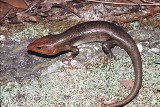
HABITATS |
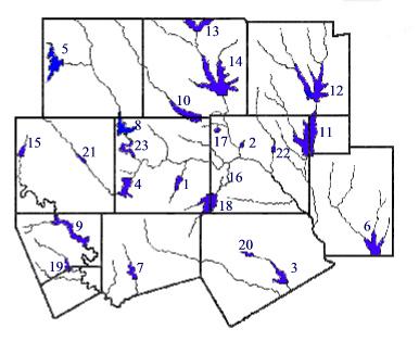
The counties that make up the Metroplex area are Collin, Dallas, Denton, Ellis, Hood, Johnson, Kaufman, Parker, Rockwall, Somervell, Tarrant, and Wise. These counties have a wide variety of habitats. This can be attributed to the diverse soil types and the many streams and lakes located in the Metroplex. Soils range from black clay to light sandy loam and are dispersed throughout the counties. The main streams in the Metroplex are various branches of the Trinity River: East Fork, Elm Fork, Clear Fork, and the West Fork. The Brazos River flows through the westernmost part. Each of these rivers and their tributaries is dammed at various sites producing sizable lakes, including Arlington, Bachman, Bardwell, Benbrook, Bridgeport, Cedar Creek, Cleburne, Eagle Mountain, Grapevine, Granbury, Lavon, Lewisville, Mineral Wells, Mountain Creek, North, Joe Pool, Ray Hubbard, Ray Roberts, Squaw Creek, Waxahachie, Weatherford, White Rock, and Worth. |
|
|
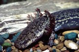
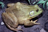
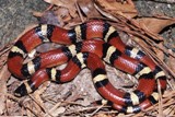
The geographical location and diverse ecological habitats of the Metroplex area puts this region at a biogeography crossroads with many western and eastern forms of reptiles and amphibians occurring here. Certain western forms, such as the green toad (Bufo debilis), the ground snake (Sonora semiannulata), the bullsnake (Pituophis catenifer), the Texas patch-nosed snake (Salvordora grahamiae), the nightsnake (Hypsiglena jani), the long-nosed snake (Rhinocheilus lecontei) and the Great Plains skink (Eumeces obsoletus) find the eastern edge of their ranges in the Metroplex. Some eastern forms, such as the banded watersnake (Nerodia fasciata), the green anole (Anolis carolinensis), the green treefrog (Hyla cinerea), the crayfish frog (Rana areolata), and the bronze frog (Rana clamitans) enter the Metroplex only in the east. The habitats of the Metroplex may be classified as the Eastern Cross Timbers, the Mesquite Grand Prairie, the Trinity River Bottoms, the Cedarlimestone Hills, the Blackland Prairie, the Fort Worth Prairie, Post Oak Belt, Rolling Plains, and Brazos River Bottoms (Texas Almanac, 1993 and Gould, et al, 1968). |
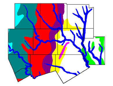 |
The Eastern Cross Timbers The Western Cross Timbers The Trinity River Bottoms The Cedar-Limestone Hills The Blackland Prairie (White) The Fort Worth Prairie The Mesquite Grand Prairie The Post Oak Belt The Brazos River Bottoms The Rolling Plains |
The Eastern Cross Timbers: This habitat runs in a north-south narrow band through eastern Denton, eastern Tarrant, and eastern Johnson counties. Soils are generally red and sandy, with less exposed rock than in the Western Cross Timbers. The woodland vegetation is dominated by post oak (Quercus stellata) and blackjack oak (Quercus marilandica), with the undergrowth consisting of green-brier (Smilax sp.) and various grasses such as little bluestem (Schizachyrium scoparium), lovegrass (Eragrostis spp.), and Indiangrass (Sorghastrum nutans) in the more open areas. The Western Cross Timbers: This region enters the Metroplex in a north-south band through the center of the western counties of Wise, Parker, Hood, and Somervell. The chief features are a sandy, rocky soil, dotted with many outcroppings of limestone and sandstone. Like the Eastern Cross Timbers, the dominant trees are post oak (Quercus stellata) and blackjack oak (Quercus marilandica). The major difference is that the oaks are much shorter and grow very close together. The Trinity River Bottoms: This region is the Trinity River valley and flood plain in all Metroplex counties except Hood and Somervell. The dominant vegetation, consisting of large deciduous trees such as sycamore (Platanus occidentalis), pecan (Carya illinoensis), Shumard red oak (Quercus shumardii), and sugarberry (Celtis laevigata) parallels the river, its forks and larger creeks. The soil is a rich humus. These forests have been largely destroyed by reservoirs and city development. Several fine stands, however, may still be seen in the city parks. The Cedar-Limestone Hills: Located in southwestern Dallas County and northwestern Ellis County along the White Rock Escarpment, this habitat is noted for its numerous outcroppings of Austin Chalk. This feature makes the area reminiscent of the Edwards Plateau of Central Texas. The typical tree of the area is juniper (Juniperus sp.). The area is a hilly section of the Mesquite Grand Prairie, and appears as a rocky ridge dividing the prairie. The Blackland Prairie: This black soil prairie of central Dallas and most of Collin, Rockwall, Ellis, and Kaufman Counties was originally grassland, but is now much altered by farming and urbanization. Climax grass vegetation, can only be found on a few protected sites in Collin, Rockwall, and Ellis Counties. Climax plant species include little bluestem (Schizachyrium scoparium), Indiangrass (Sorghastrum nutans), switchgrass (Panicum virgatum), sideoats grama (Bouteloua curtipendula), tall dropseed (Sporobolus asper), and Texas wintergrass (Stipa leucotricha). In heavily grazed pastures, the tall grasses have been replaced by buffalograss (Buchloe dactyloides), Johnson grass (Sorghum halepense), and other grasses of disturbed sites. Trees invading the area are the bois d'arc (Maclura pomifera), winged elm (Ulmus alata), and cedar elm (Ulmus crassifolia). The Fort Worth Prairie: This area runs in a broad band generally from north to south through eastern Wise and the western half of Denton counties; eastern Parker and the western two thirds of Tarrant counties; and eastern Hood and western Johnson Counties. Important features include many limestone outcroppings located on gently rolling grassland. The vegetation once consisted of little bluestem (Schizachyrium scoparium), Indiangrass (Sorghastrum nutans), and blue grama (Bouteloua gracilis). These grasses have been replaced in much of the area by less productive species such as buffalograss (Buchloe dactyloides), and silver bluestem (Bothriochloa saccharoides). Yucca (Yucca sp.) and prickly pear (Opuntia sp.) are abundant. The Mesquite Grand Prairie: This area covers the southeastern portion of Tarrant and Johnson Counties and the extreme western portions of Collin, Dallas, and Ellis Counties. The area is characterized by overgrazed Blackland Prairie with an abundance of mesquite (Prosopis glandulosa). Much of the area has been plowed or urbanized. The Post Oak Belt: Scattered relict localities occur only in Kaufman and extremely southeastern Dallas Counties. This area was typically a savannah type with scattered trees and prairie grasses. Due to intensive overgrazing in both the past and present and fire control, much of the area has become densely covered with post oak (Quercus stellata) and blackjack oak (Quercus marilandica). Also, much of the area has been stripped of all vegetation and replaced with coastal bermuda grass (Digitaria sp.). The climax grass vegetation consists of little bluestem (Schizachyrium scoparium), Indiangrass (Sorghastrum nutans), switchgrass (Panicum virgatum), purpletop (Tridens flavus), silver bluestem (Bothriochloa saccharoides), and Texas wintergrass (Stipa leucotricha). The Brazos River Bottoms: The Brazos River barely enters the study area in Somervell, Hood, and southwestern Parker Counties. This area is characterized by narrow bottom land with sandy soils and steep hillsides with exposed outcroppings of limestone and sandstone. The tree species that occur in this area are pecan (Carya illinoensis), eastern cottonwood (Populus deltoides), and sycamore (Platanus occidentalis) with the hillsides covered with junipers (Juniperus sp.). The river has extensive shallow ripples areas. The Rolling Plains: This area barely enters the study area in the northwestern part of Wise County and western Parker County. Typically the area is a rolling to rough terrain of mixed grasses. There are considerably more outcroppings of limestone in the western part of the Rolling Plains than in the eastern area. Soils basically range from sands along rivers and streams to compact clays on red bed clays and shales. The climax grasses consist of big bluestem (Andropogon gerardii), little bluestem (Schizachyrium scoparium), sand bluestem (Andropogon hallii), sideoats grama (Bouteloua curtipendula), and Indiangrass (Sorghastrum nutans) in the more sandy areas. Tighter soils contain shorter grasses such as sideoats grama (B. curtipendula) and buffalograss (Buchloe dactyloides). Mesquite (Prosopis grandulosa) is a common invader in highly grazed areas of all soil types. |