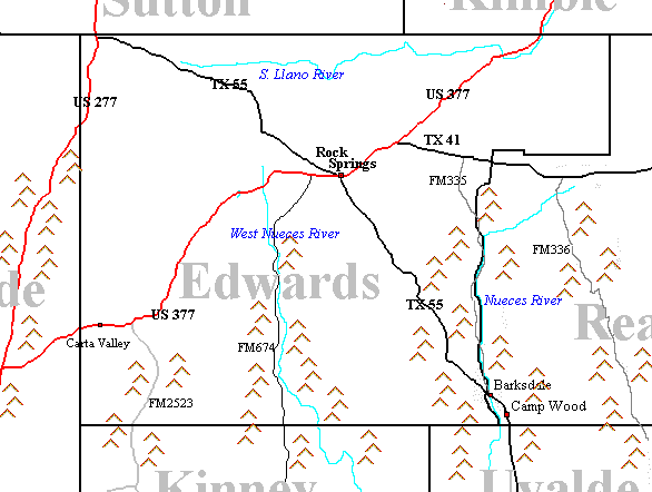
Edwards is the 247th largest of the
254 counties in Texas, consisting of 2,076 square miles.
Much of Edwards County is composed of Cretaceous
Limestone in the northern section, which lies on the Edwards Plateau.
The areas in the southeast of the county, which lie on the Balcones Escarpment,
are composed of intrusive volcanic hills.
Climate
Rainfall in Edwards county averages 23.60 inches per year compared to
the Texas average of 21.0 inches per year. The eastern and southern portion
of the county receive slightly higher amounts of rain than the western. On average
the first freeze generally occurs around Nov 21.
Vegetation throughout the northern and western part of the county is predominantly grass, yucca, cacti, and lechuguilla. Areas in the southern and eastern portion of the county also
support larger shrubs such juniper, mesquite and shrub oaks.Additionally, in
the higher elevations, Pinyon Pines and larger oaks can be found.
Population
Edwards County had an estimated population of 2,295 in 1991. The
county seat of Edwards is Rocksprings and the next most significant city is Barksdale. Edwards county is a rural county with a 1990 population density 0.70 residents
per square mile.
Popular L. alterna Localities
Edwards is probably one of the most under-collected L.alterna counties, mainly from lack of effort on the part of collectors. There is a tremendous amount of habitat that is virtually
untapped as an alterna resource, which is surprising considering it's accessability.
US 277, North of Loma Alta
Edwards County overlaps a 16 mile section of US 277 north of Loma Alta. Collecting here is very difficult, as the hills are relatively low and unfractured, spaced far apart and set far
from the roadway. While it is almost certain that alterna have been collected here, no one has stepped forward to claim ownership of a specimen from this area. There is at least one verified DOR from this area. Rock formations are of Cretaceous
Limestones.
US 377
This area has produced a small number of alterna. While having some nice
cuts, for the most part the hills are relatively low and unfractured. There are a number of cuts on this road, but they are spaced very widely. This road cuts a large swath straight thru the heart of Edwards County. Roadcuts here are made predominantly of Cretaceous Limestones.
There is one infamous light phase blairi DOR from the Carta Valley area.
FM 2523
There is a small(12 miles) portion of FM2523 in Edwards county. It's vegatation is completely Trans-pecos but it has only a few low cuts. While this road cuts through quality habitat, most of it is too far from the roadway to be worthwhile. There has been one confirmed animal from this road, but it is from the Kinney County portion off the road.
FM 674 (Brackettville Road)
Both small and large roadcuts are present here with an enormous (3+ mile) cut at the southern
portion of the Edwards County part of the road. This road progresses into Kinney County and is
approximately 70 miles long, winding along the West Nueces River with many hills, canyons and ravines. There are two known alterna specimens from this road, one from each county. Strangely the habitat gets more desert-like the further south you go, with most of the road having vegatation more like the Hill Country.
Habitat
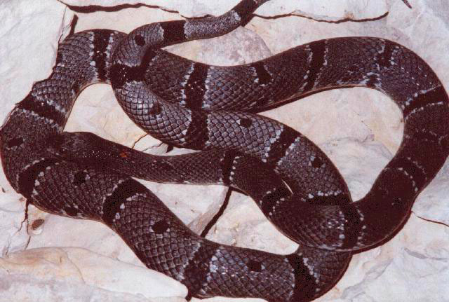
Specimens
|
|
- 807.jpg - Richard McNabb
(Blairi is from Kinney County portion of FM674)
|
Other Possible Locations
TX 55, North of Rocksprings
This area is relatively high on the Edwards Plateau. While it does transect L.alterna
habitat, there are no appreciable roadcuts and there have been no rumored collections.
TX 55, South of Rocksprings
This area begins to drop off the plateau and there are a number of good road cuts on the southern portion of the road. While there are no verifiable specimens, a DOR is rumored from
north of Camp Wood. The vegatation severely changes as this road progresses south, with the
thorn of the Trans-Pecos diminishing and the cedar/mesquite of the Hill Country taking over.
US 377, North of Rocksprings
While the habitat of southern portion of this road looks very Trans-Pecos, there are few to no
rock cuts bisecting this section. The northen portion has many cuts, but the vegatation is more Hill Country, than Trans-Pecos. While it is probable that L.alterna exist here none have been rumored to have been collected here.
FM 335, East of Rocksprings
A very probable locale for L.alterna, though none have been collected here. This road is a very
windy road, meandering in and out of a creek line, with numerous ravines and canyons. The vegetation is all of a Hill Country type, Mesquite, Cedar, and Scrub Oaks.

